Glebe Island Silos
A now approved Modification DA that was seeking consent to allow the general advertising roof signage on the Glebe Island Silos to continue to be displayed for a further three years.
A now approved Modification DA that was seeking consent to allow the general advertising roof signage on the Glebe Island Silos to continue to be displayed for a further three years.
Welcome to the Project Listing for the Glebe Island Silos Advertising Signage Planning Application. The Application is being made under Section 4.55(2) of the Environmental Planning and Assessment Act 1979 and is called a Modification Application. The existing signage is the subject of a valid development consent being DA 21/13182, which will expire on 9 September 2025. The Modification Application is being made to enable the advertising roof signage on the Glebe Island Silos to continue to be displayed for a further three (3) years.
This Modification Application does not propose any changes to the physical form of the approved signage structure, the 11 pm curfew or the intensity of the illumination. It will maintain the existing Public Benefit Agreement with the Inner West Council that provides $140,539 per annum (plus GST), increasing annually with CPI, for the duration of the consent. The funding that is provided under this Agreement supports heritage conservation works in the Inner West Local Government Area.
In this Listing, we describe The Modification Application and the supporting environmental investigations into heritage impact, visual impact, ecology, lighting impact and traffic safety that accompany the Application. You can use the feedback form at the bottom of the Listing to ask a question to Eye Drive Sydney, who is the Applicant.
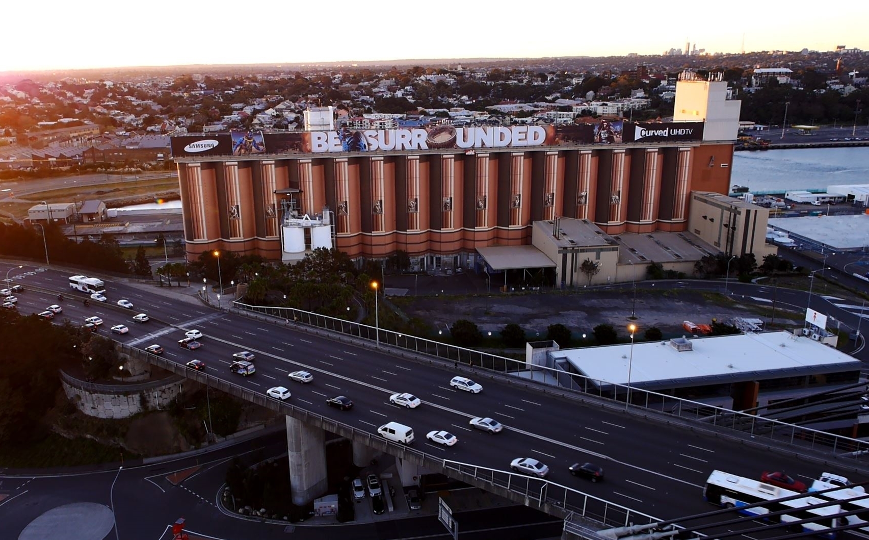
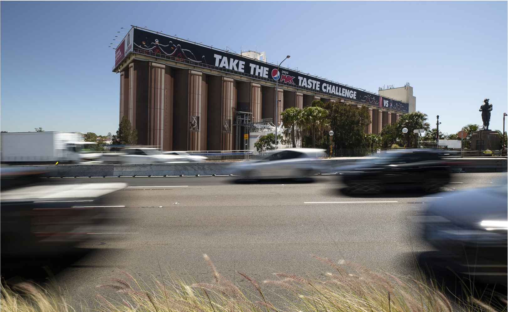
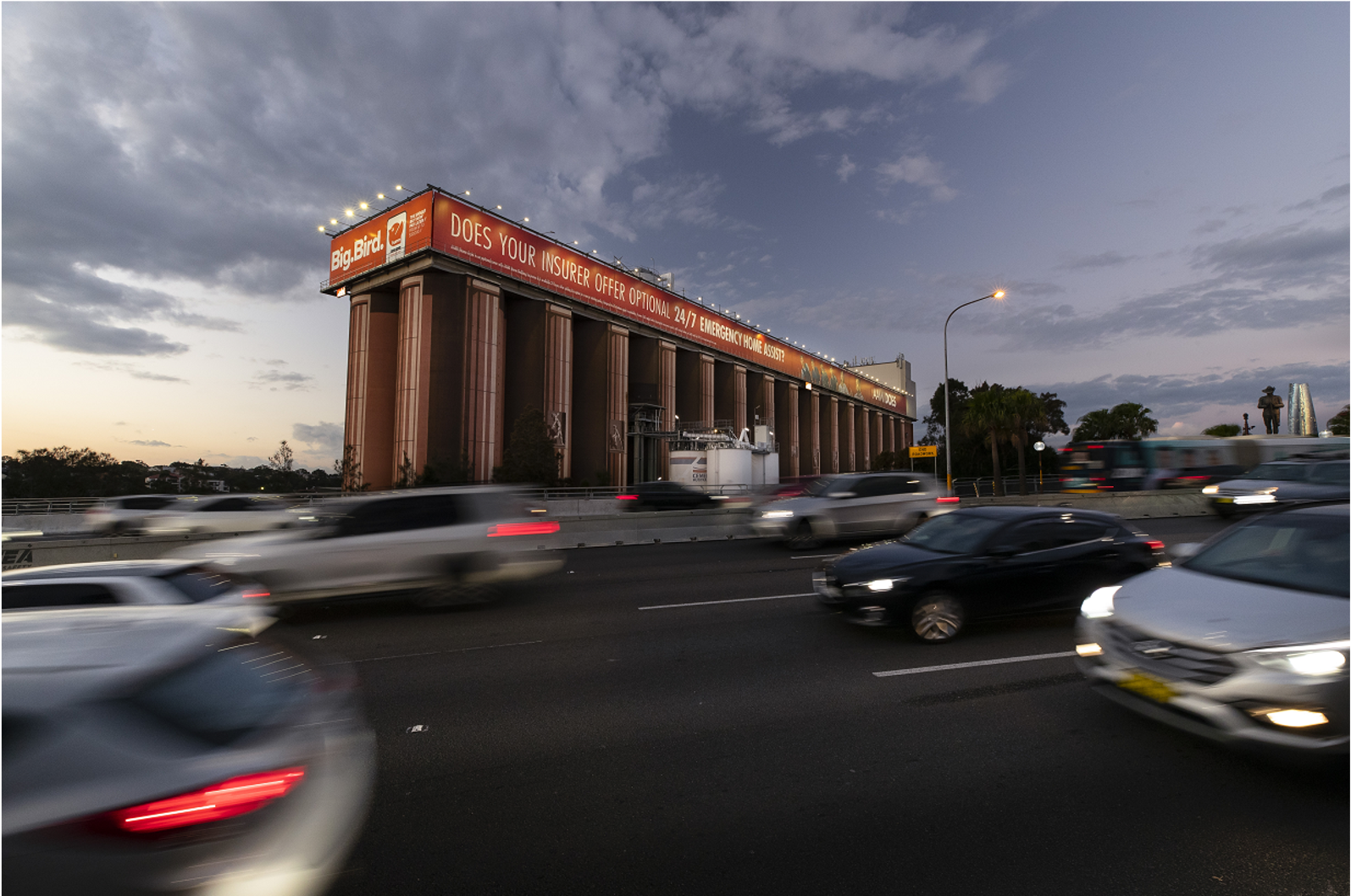
The Advertising Sign on the Southern Elevation of the Glebe Island Silos
Source: oOh!media
Glebe Island Silos, Rozelle
Inner West Council
NSW Minister for Planning & Public Spaces
Advertising & Signage
Modification DA Approved
Planning Portal reference number: PAN-541019
Consent authority’s reference number: DA21/13182 MOD 1
Eye Drive Sydney Pty Ltd
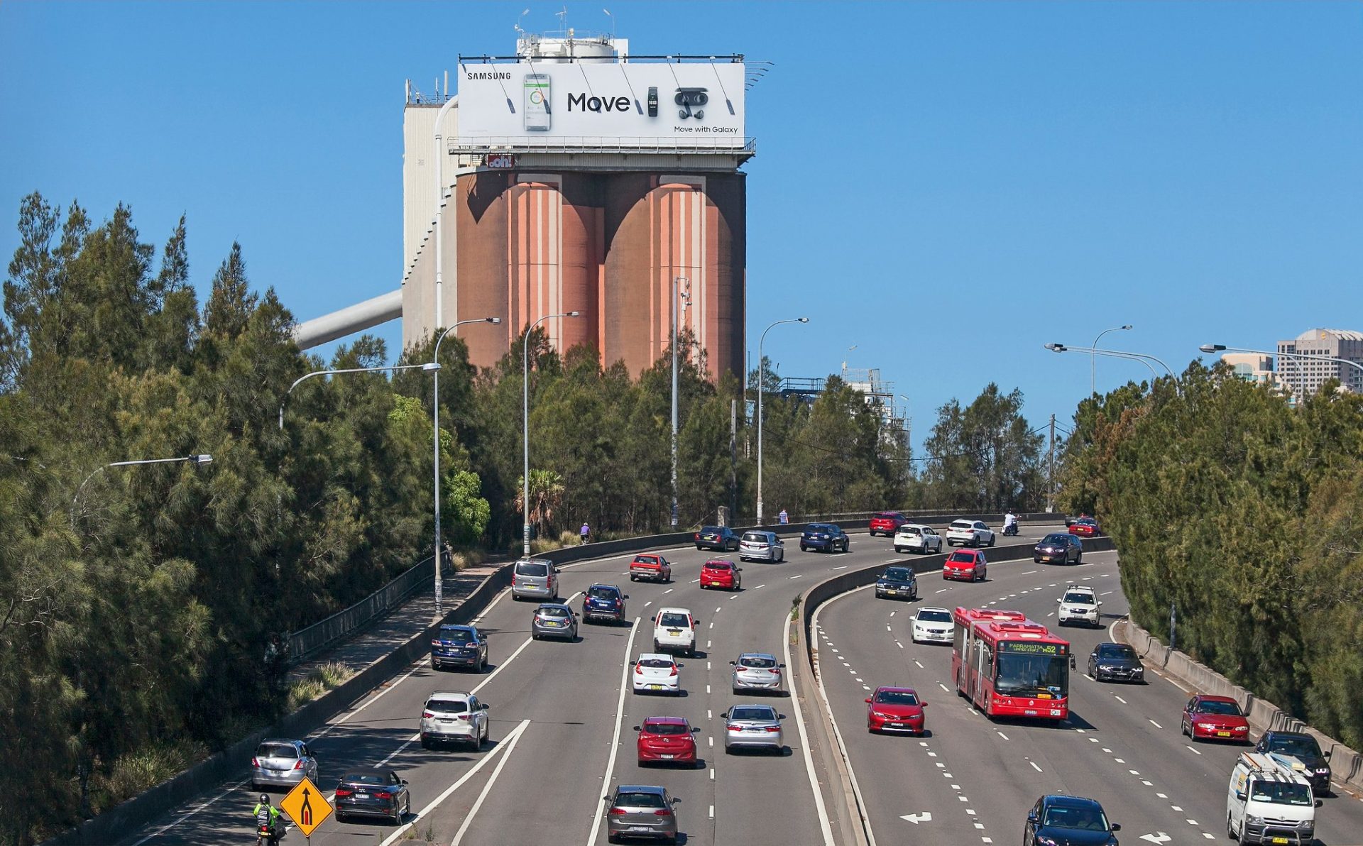
The Advertising Sign on the Western Elevation of the Glebe Island Silos
Source: oOh!media
Eye Drive Sydney Pty Ltd, a subsidiary of oOh!media Limited, is the Applicant progressing this Section 4.55(2) Modification Application. The site is owned by the Port Authority of NSW (hereafter referred to as the Port Authority). Eye Drive Sydney has a commercial lease with the Port Authority for the Glebe Island Silos advertising signage. The Port Authority has provided owners consent for the Modification Application.
While the site is located within the Inner West Council Local Government Area, the NSW Minister for Planning and Public Spaces is the Consent Authority for this Application. The Application is assessed on behalf of the Minister by the NSW Department of Planning, Housing and Infrastructure (NSW DPHI).
Advertising roof signage has existed on the Glebe Island Silos for approximately 32 years and has been the subject of numerous Development and Modification Applications over that time. When originally constructed the signage was considerably larger covering the eastern, western and southern rooftop elevations of the Silos. Today, the signage only covers the southern and western rooftop elevations as required under the planning controls that are contained in the Glebe Island Silos Development Control Plan 2004.
The Modification Application does not look to make any physical change to the location, number or dimensions of the signs. It does not alter the intensity of illumination or the 11 pm curfew. The Modification Application is required because the existing development consent that provides for its display being DA 21/13182 will expire on 9 September 2025. The Modification looks to extend this consent for a further three (3) years.
The independent specialist investigations that assess the visual, heritage, ecological, lighting and traffic safety impacts of extending the consent duration for a further three (3) year term have not identified any matters that would make the ongoing dsiply of the advertising on the Silos as having an undesirable or adverse impact on the existing and proposed future surrounding land uses.
Eye Drive Sydney Pty Ltd lodged the Modification Application on the NSW Planning Portal on 5 June 2025. The Planning Portal Reference Number for the Application is PAN 541019. The Application was placed on public exhibition, which ran between 11 and 24 June 2025. The Modification Application is now under assessment.
Completed
Completed
Lodged
Completed
Approved
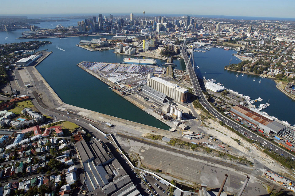
The Glebe Island Silos are located in Sommerville Road, Glebe Island. The site is located within the Inner West Local Government Area and is under the care, control and ownership of the Port Authority.
Glebe Island is a working port used for deep water wharfage and storage, including bulk cement, sugar, gypsum, and loading and unloading. It is a reclaimed peninsula to the south of Balmain and is surrounded by water to the north (White Bay), south (Rozelle Bay) and east (Johnstons Bay).
The site is surrounded by major roads, which include the Western Distributor (Anzac Bridge), City West Link, Victoria Road and James Craig Road.
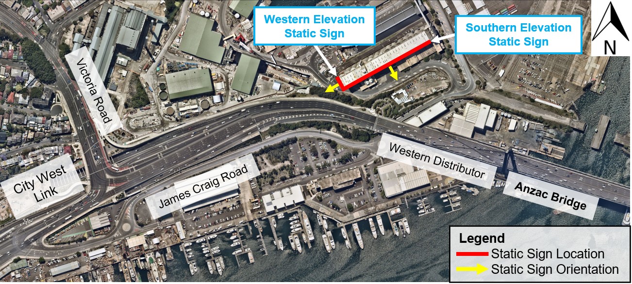
Local Road Network Surrounding Glebe Island
Source: Bitzios Consulting Transport Safety Assessment 2025
Glebe Island forms part of the land that has been designated by the NSW Government as the Bays Precinct, The Precinct is 95 hectares in area and includes, the White Bay Power Station, Rozelle, Rozelle Rail Yards, Rozelle Bay and White Bay. The Bays Precinct has historically been utilised for maritime, light industrial and working harbour purposes. Several NSW Government agencies own, manage, and use the waterways, wharves, and infrastructure of Glebe Island, which makes the Port Authority one of the key stakeholders within the Precinct.
The Bays Precinct is an area that is undergoing extensive strategic planning by the NSW Government. The long-term vision will deliver a connected and vibrant Precinct that encompasses a mix of employment, housing and recreational land uses all serviced by the new Bays Metro Station that is due for completion in 2032. The Plans recognise the importance of retaining the existing Port and a working harbour at Glebe Island.
The strategic plans that apply to the Bays Precinct and the timeframe for realising the development of the Precinct are described below in the Project Listing.
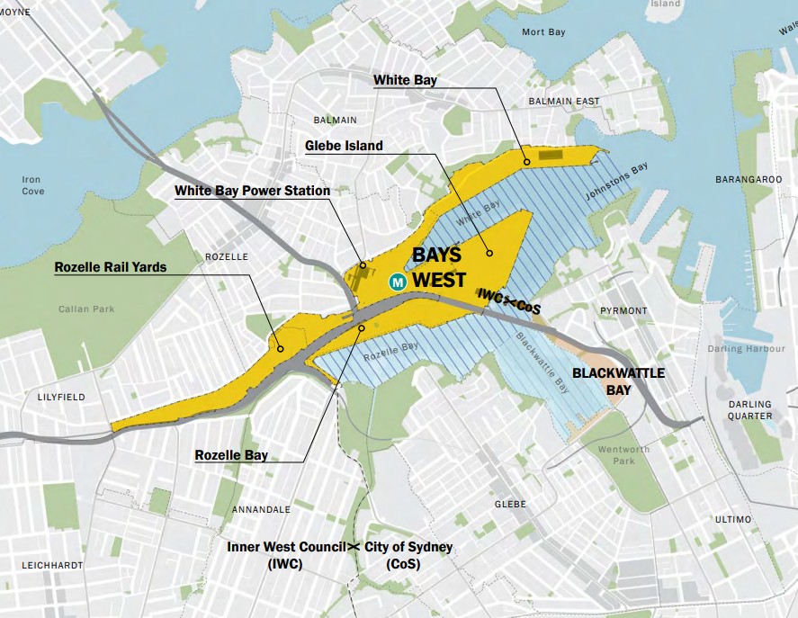
The Bays Precinct
Source: Bays West Strategic Place Framework 2021
The development statistics for the existing western and southern advertising signs are set out below. The Modification Application does not change any of these statistics.
| Statistics | Western Sign | Southern Sign |
|---|---|---|
| Dimensions of signage | 6.1 metres height x 22.1 metres in length | 6.1 metres height x 170 metres in length |
| Height of the signage to the top of the sign | Silos parapet height approximately 50 metres | Silos parapet height approximately 50 metres |
| Advertising display area | 134.8 square metres | 1037 square metres |
| Form of illumination | External – 6 cantilevered down lights | External – 43 cantilevered down lights |
| Hours of illumination | Night Illumination until 11pm | Night Illumination until 11pm |
| Signage Categorisation | General Advertising Roof Sign | General Advertising Roof Sign |
View to the Glebe Island Silos Advertising Signs from the ANZAC Bridge
Source: oOh!media
The future planning of the Bays Precinct, inclusive of the Glebe Island Silos is established under the following strategic plans:
• Bays West Strategy 2021;
• Bays West Place Based Transport Strategy;
• Bays West Stage 1 Master Plan and Rezoning 2022;
• Stage 1 Bays West-White Bay Power Station (and Metro) Design Guide 2022; and
• Bays West Transport Oriented Development Accelerated Precinct.
Each of these Plans is discussed below.
This Strategy identifies the Glebe Island Silos as an iconic building element that reinforces the distinctive industrial maritime character of Bays West. Under the Strategy the Silos are retained and used for storage or repurposed. The Strategy identifies ten (10) Sub-Precincts as illustrated below. Each Sub-Precinct will undergo a master planning and rezoning process. The Silos are in Sub-Precinct 3. The first precinct to undergo master planning and rezoning is Sub-Precinct 1. The plans for Sub-Precinct 1 are discussed below and will occur outside of the three (3) year extension to the Glebe Island Silos advertising sign consent duration.
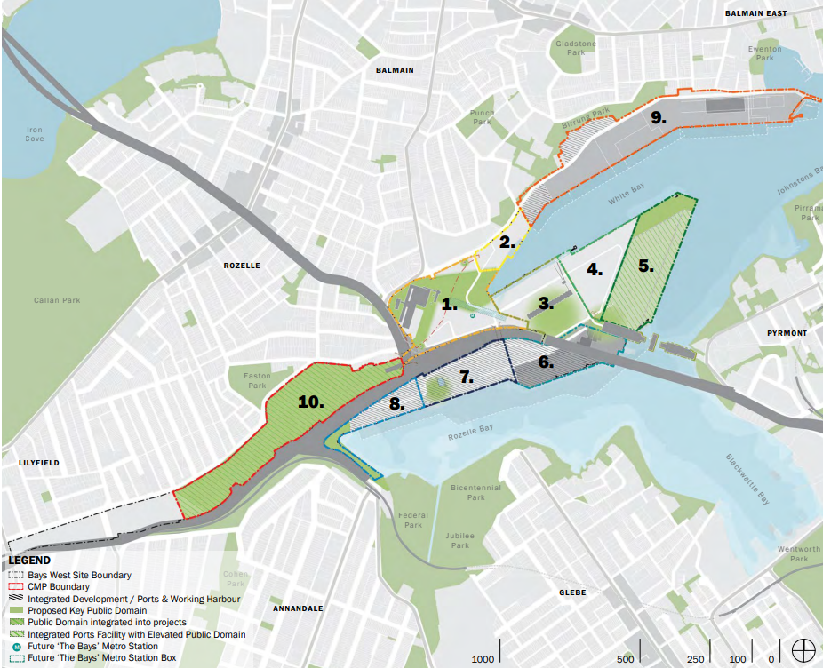
The Bays Precinct Sub-Precinct Plan
Source: Bays West Strategic Place Framework 2021
The Strategy looks to improve walking and cycling networks, lower car usage and increase connections to public transport once The Bays Metro Station is opened in 2032. The disused Glebe Island Bridge is proposed to be repurposed as a major active transport corridor between Rozelle and Pyrmont. These transport initiatives will occur outside of the proposed three year extension to the Glebe Island Silos advertising sign consent duration.
Sub-Precinct, White Bay Power Station (and Metro) has been Master Planned and Rezoned under Bays West Stage 1. The development of Bays West Stage 1 will take 5-8 years, and will coincide with the opening of The Bays Metro Station in 2032.
The Sub-Precinct is broken into four (4) development sites. As illustrated in the plan below the Glebe Island Silos are located immediately adjacent to Site A, which encompasses the Metro Station. No residential development is proposed for Site A presently. Site B is located to the Southwest of the Glebe Island Silos and is proposed to be a vibrant mixed-use development that includes high-density residential development. This residential development will not coincide with the proposed three (3) year extension to the consent duration.
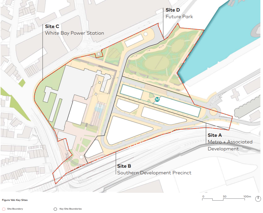
Bays West Stage 1 Key Development Sites
Source: Bays West Stage 1 Master Plan and Urban Design Framework 2022
Bays West has been identified by the NSW Government as a Transport Oriented Development (TOD) Accelerated Precinct. The Bays West TOD Accelerated Precinct builds on the vision of the Bays West Place Strategy. The TOD rezoning will go on public exhibition in mid-2025.
The Modification Application applies to the development consent DA21/13182 MOD 1 that was granted on 9 September 2022 for the existing advertising roof signage that is on the western and southern elevations. The Modification Application Consent is DA 2/13182 MOD 1.
The Application is lodged under Section 4.55 (2) of the Environmental Planning and Assessment Act 1979. Under the provisions of Section 4.55(2), a consent authority must be satisfied that the consent, as modified, is substantially the same development as the original consent.
This Modification seeks consent to modify Conditions A2, A4 and A5 of the Consent:
• Condition A2 will be modified by updating the technical reports submitted with the DA with the new suite of technical reports that support this Modification that relate to heritage, traffic safety, lighting, visual impact, ecological assessment, and the statement of environmental effects.
• Condition A4 will be modified to correct a drafting error that occurred in the consent document.
• Condition A5 will be modified by extending the duration of the consent for an additional three (3) years. A three (3) year extension to the duration of the development consent to a six (6) year duration since the initial consent was issued in 2022 is within the maximum ten (10) year consent duration term prescribed for roof advertising signs under Clause 3.19 of Chapter 3 of the State Environmental Planning Policy (Industry and Employment) 2021.
This Modification Application does not propose any changes to the physical form of the approved signage structure, the hours of operation or the illumination of the signage. The Modification Application will maintain the existing public benefit agreement with the Inner West Council.
The Modification Application Package comprises the following documents:
• Statement of Environmental Effects (SEE) prepared by Urban Concepts dated May 2025.
• Visual Impact Assessment Report prepared by Urbis dated 27 March 2025.
• Heritage Impact Assessment Report prepared by NBRS dated 13 March 2025.
• Lighting Impact Assessment Report prepared by Electrolight Australia Pty Ltd dated 24 February 2025.
• Traffic Impact Assessment Report prepared by Bitzios Consulting dated 11 February 2025.
• Ecological Impact Assessment prepared by Cumberland Ecology dated 21 February 2025.
• Structural Certification prepared by Lewis Consulting Structural Engineers dated 27 May 2025
The Modification Application Package was lodged on the NSW Planning Portal on 5 June 2025. It will then be assessed by the NSW Department of Planning, Housing and Infrastructure on behalf of the NSW Minister for Planning and Public Spaces.
As part of the usual process of assessment, the Modification Package and all supporting documentation will be notified to local businesses and residents and placed on public exhibition between 11 and 24 June 2025. At this time, submissions can be made to the NSW DPHI about the Application. All submissions must be made in writing through the NSW Planning Portal. Submissions must NOT be made to UrbanTalk.
Section 4.55(2) of the EP&A Act 1979 requires that a modified development be substantially the same as the original development that was approved. The proposed Modification satisfies this requirement for the following reasons:
• Both signs retain their existing physical appearance in the skyline because there is no change to the dimensions, advertising display area, height, or orientation of the two signs.
• There will be no change to the light intensity, light spill, reflectivity or glare generated by the signs when they are illuminated.
• Both signs will continue to be illuminated during nighttime hours until 11 pm.
• The signs will continue to be used to display third-party goods and services on a twenty-eight (28) day rotation. The advertising copy will continue to be printed on vinyl skins that are tensioned over the steel support structure.
• Maintenance of the signs will continue to occur as and when required under the lease term and will utilise the existing steel gantry.
• Despite changes to the surrounding area associated with the urban renewal of the Bays Precinct, the subject site is still within an active industrial precinct and continues to be zoned as Port and Employment under the Precincts SEPP. In granting consent to the signage in 2022, the NSW Minister for Planning and Public Spaces (who is the consent authority for this Application) accepted that the signage was consistent with the Ports and Employment Zone objectives.
The proposed Modification Application to extend the duration of the consent for the roof signage on the Glebe Island Silos for a further three (3) year term has strategic merit for the following reasons:
• A three (3) year extension to the Development Consent will expire in or around September 2028, which is ahead of the forecast completion of the Bays Metro Station in 2032 and the development of the White Bay Power Station Sub Precinct (Precinct 1 under the Bays West Strategy) which will take 5-8 years to complete.
• There is little or no prospect of any residential development being completed within proximity of the Silos in Sub Precinct 1 within the next three (3) years as the rezoning package was only approved by the NSW Government in December 2022.
• Land surrounding the Glebe Island Silos has been set aside temporarily to support the delivery of essential infrastructure across Sydney. Land to the west of the Silos is identified as ‘Bays Temporary Land’ to facilitate construction activities. The Port Authority land to the east and north-east of the Silos is set aside as a Western Harbour Tunnel Temporary Use Zone.
• The Port Authority holds a current commercial lease with the Applicant, Eye Drive Sydney Pty Ltd for the ongoing display of the existing signage at the top of the Glebe Island Silos on the basis that Sub-Precincts 3, 4 and 5 under the Bays West Strategy would not be developed before 2030.
North West View of Glebe Island Silos Signs from Bays West Stage 1 Site
Source: oOh!media
The relevant Environmental Planning Instruments (EPIs) and Development Control Plans (DCPs) that apply to the Modification are listed below.
• State Environmental Planning Policy (Precincts – Eastern Harbour City).
• State Environmental Planning Policy (Industry and Employment) 2021 (Chapter 3, Schedule 5).
• Transport Corridor Outdoor Advertising and Signage Guidelines 2017.
• Glebe Island and White Bay Master Plan 2000.
• Glebe Island Silos Advertising Signage Development Control Plan.
• Bays West Place Strategy and its supporting plans.
• State Environmental Planning Policy (Biodiversity and Conservation) 2021.
The existing development consent is accompanied by a Public Benefit Agreement that provides the Inner West Council with a monetary contribution of $140,539 per annum plus GST, increasing annually with CPI, for the duration of the consent. The contribution is to be used for heritage conservation works in the Inner West Council Local Government Area. Pending the approval of the Modification Application, the public benefit agreement will remain in place for a further three (3) years.
This Modification Application does not propose any changes to the intensity or the hours of operation of the illumination of the approved signage. The existing 11 pm curfew is retained.
The Lighting Impact Assessment by Electrolight Australia that accompanies the Modification Application has reviewed the compliance of the signage lighting against the relevant legislation in the Australian Standards AS 4282-2023, The Control of the Obtrusive Effects of Outdoor Lighting, and the NSW Transport Corridor Advertising and Signage Guidelines 2017. The assessment has found the signage lighting to be compliant with these standards. The signs currently operate at 58 cd/m2, which is well under the allowable limit of 350 cd/m2 under the Australian Standard and 200 cd/m2 under the Transport Corridor Guidelines 2017.
Electrolight Australia has confirmed that if residential development were to occur within Stage 1, Site B (Southern Development), within the next three (3) years, the existing luminance of the signage can remain unchanged as it remains compliant with all relevant controls and standards.
Western and Southern Flood Lit Signs
Source: oOh!media
Cumberland Ecology was commissioned to prepare an Ecological Assessment Report (EAR) that addresses the NSW Biodiversity Conservation Act 2016 and the Commonwealth Environment Protection and Biodiversity Conservation Act 1999.
The EAR has considered the impacts of extending the display of the advertising on the Silos (noting that no changes are proposed to the existing signage including its illumination) on the nocturnal birds and bats and considers recent changes to the locality and intended future developments.
Cumberland Ecology EAR has concluded that there is no adverse impacts on either birds or bats within the vicinity of the site.
Urbis was commissioned to undertake a Visual Impact Assessment (VIA), which utilised the Urbis methodology that is based on 30 years of academic research and publications by industry leaders.
The VIA examined fourteen (14) views within a 500-800 metre visual catchment of the Silos. Urbis concludes that the signage generates a low level of visual effects on view composition, visual character, and visual resources of the site. Urbis states that the existing level of visual effects and impacts generated by the existing signage are reasonable and acceptable, and they support the three (3) year extension of consent.
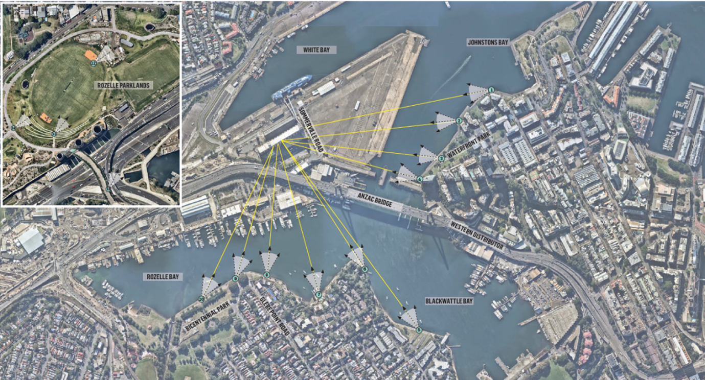
View Impact Assessment Plan
Source: Urbis Visual Impact Assessment 2025
Bitzios Consulting has undertaken a Traffic Safety Assessment (TSA). Bitzios assessed the compliance of the proposal against all relevant traffic safety assessment criteria and has determined that the signs are fully compliant. The TSA concludes that the ongoing display of the signs should be approved, for the following reasons:
• The illumination, size and location of the signs will not change.
• Given the elevated location of the signs, they do not obstruct any view or restrict a sight distance to any intersections, traffic control devices, vehicles, pedestrians or cyclists.
• The signs have been located on the Silos for 32 years, making them insignificant to most drivers. It would be a rare event for the signage to be purposefully glanced at by a passing driver.
• Throughout the 32 years, there has been no evidence that the signs have reduced safety in the past and is unlikely in the future due to their location within a driver’s ordinary field of view.
• The 5-year crash data within 500m of the signs show a low crash rate.
• The sign complies with Industry and Employment SEPP 2021, Transport for NSW Advertising Sign Safety Assessment Matrix and the Transport Corridor Outdoor Advertising and Signage Guidelines 2017.
The Silos are identified as a local heritage item in Schedule 4 of the Precincts SEPP 2021 and as a heritage item on the Port Authority of NSW Section 170 Register. The Silos are within proximity to Heritage Item 5 – Monument, Glebe Island and Heritage Item 11 – White Bay Power Station complex and various items on the State Heritage Register as illustrated by the map below.
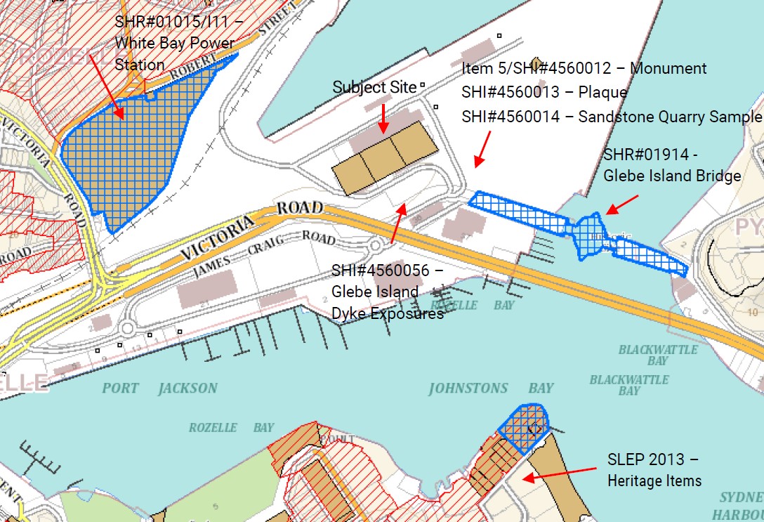
Heritage Items in the Vicinity of the Glebe Island Silos
Source: NBRS Heritage Impact Statement 2025
NBRS has undertaken a Heritage Impact Statement (HIS) against the relevant heritage controls. NBRS conclude that the consent for advertising signage atop the existing Glebe Island Silos would not diminish the appreciation or understanding of the Silos structures and would not impact the heritage significance of the site for the following reasons:
• Advertising signage atop the Glebe Island Silos does not diminish the significance or appreciation of the distinctive cylindrical form and large scale of the structures as it does not obscure nor damage the distinctive built form of the Silos.
• The size and proportion of the signage is proportional to Silos which retains the original form and scale of the Silos.
• No changes will be made to the physical and visual relationship between surrounding historic items.
• Whilst lighting is a non-historic element, it sits alongside other lighting features on roadways and the foreshore.
• The Glebe Island Olympic Mural is not linked to the significance to the Silos. There will be no changes to the mural.
• Illumination levels and operations hours will be maintained.
Lewis Consulting Structural Engineers has undertaken a structural assessment of the steel framing system that supports the advertising signs. The assessment considered:
• AS 1170 Structural Design Actions (AS1170.0-2002, AS1170.1-2002, AS1170.2-2021, AS1170.4-2007);
• AS 4100 Steel Structures – 2020
Following the structural analysis, Lewis Consulting concluded that both the western and southern steel sign framing is structurally adequate and compliant with the Australian Standards.
Eye Drive Sydney Pty Ltd, is a wholly owned subsidiary company of oOh!media Limited. Eye Drive Sydney is the Applicant progressing the Modification Application.
oOh!media is a leading Out of Home media company that is enhancing public spaces through the creation of engaging environments that help advertisers, landlords, leaseholders, community organisations, local councils and governments reach large and diverse public audiences.
The Company’s extensive network of digital and static asset locations across Australia and New Zealand, includes roadsides, retail centres, airports, train stations, bus stops, office towers and universities.
UrbanTalk acknowledges the Aboriginal and Torres Strait Islander peoples as the first inhabitants of this nation and the traditional custodians of the lands where we live, learn and work.
The Commons Surry Hills,
Level 1, 285A Crown Street,
Surry Hills, NSW, 2010
© Copyright 2025 UrbanTalk. All Rights Reserved.
ABN 17 646 538 203